| Author |
Message |
Adept Greytalker
Joined: Aug 28, 2004
Posts: 348
Send private message
|
Mon Jan 07, 2013 3:48 am
Blank Map/Player Map of the Great Kingdom
|
 REPLY
QUOTE
TOP
REPLY
QUOTE
TOP
|
|
Hi all,
So, today, I am looking for, as the title says, a blank map of the Great Kingdom?
Like, my English fails me here, a blank map where only the geographical features are lined out,
but with no place names?

Still hungover from NYE, and wishing you all a good start into the post-apocalypse,
Rafe
_________________
"A Minstrel's Memory": PBPs & Other Games, since 2005.
|
|
|
Black Hand of Oblivion
Joined: Feb 16, 2003
Posts: 3835
From: So. Cal
Send private message
|
Mon Jan 07, 2013 4:20 am
|
REPLY
QUOTE
TOP
|
|
Anna has mapped all of the Great Kingdom. If you download the PDFs of her maps, each one is set up such that everything is in layers. You can turn off any names, town locations, roads, borders- everything. The only thing that they don't have is a hex grid (which would make them near perfect). You can find the maps HERE.
_________________
- Moderator/Admin (in some areas)/Member -
|
|
|
Adept Greytalker
Joined: Aug 28, 2004
Posts: 348
Send private message
|
Mon Jan 07, 2013 6:28 am
|
REPLY
QUOTE
TOP
|
|
 Wow, what an awesome collection! Wow, what an awesome collection! 
Thanks, Ceb!
_________________
"A Minstrel's Memory": PBPs & Other Games, since 2005.
|
|
|
Adept Greytalker
Joined: Aug 28, 2004
Posts: 348
Send private message
|
Mon Jan 07, 2013 7:03 am
|
REPLY
QUOTE
TOP
|
|
On second thought... Isn't there something out there that is a bit more printer-friendly?
Like, I think I saw a black & white map somewhere, many, many years ago...
_________________
"A Minstrel's Memory": PBPs & Other Games, since 2005.
|
|
|
Grandmaster Greytalker
Joined: Nov 07, 2004
Posts: 1846
From: Mt. Smolderac
Send private message
|
Mon Jan 07, 2013 11:12 pm
|
REPLY
QUOTE
TOP
|
|
|
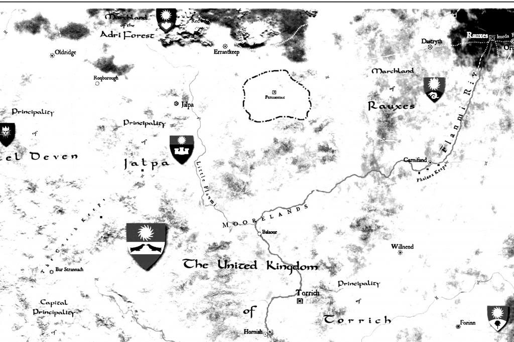
There's this map, which would probably be the easiest of any I've seen to edit the place names out of and yet still remain pretty printer-friendly.
|
|
|
Adept Greytalker
Joined: Aug 28, 2004
Posts: 348
Send private message
|
Tue Jan 08, 2013 3:47 am
|
REPLY
QUOTE
TOP
|
|
Yeah, that one might do the trick! Thank you!
But, really, aren't there at least B&W maps from the Flanaess?
That might be another way to get there...
_________________
"A Minstrel's Memory": PBPs & Other Games, since 2005.
|
|
|
Grandmaster Greytalker
Joined: Nov 07, 2004
Posts: 1846
From: Mt. Smolderac
Send private message
|
Tue Jan 08, 2013 7:55 am
|
REPLY
QUOTE
TOP
|
|
|
There's a decent black and white map, shown on Soda Bob's site here that someone modified with roads and population centers in red ink. The original still has nation names and political boundaries, which might be less easy to edit out. Plus I can't remember what product it appears in. I've seen some b&w maps of other areas of the Flanaess, in various products, but never one that included the eastern half.
|
|
|
GreySage
Joined: Aug 03, 2001
Posts: 3310
From: Michigan
Send private message
|
Tue Jan 08, 2013 9:34 am
|
REPLY
QUOTE
TOP
|
|
Here's a section of Anna's map of the Great Kingdom. I copypasted it (alt-print screen) into some photo-editing software, changed it to black and white, and increased the brightness and contrast settings to 100%. It took a minute or two and the result is about as printer-friendly as one can expect.
|
|
|
GreySage
Joined: Aug 03, 2001
Posts: 3310
From: Michigan
Send private message
|
Tue Jan 08, 2013 9:56 am
|
REPLY
QUOTE
TOP
|
|
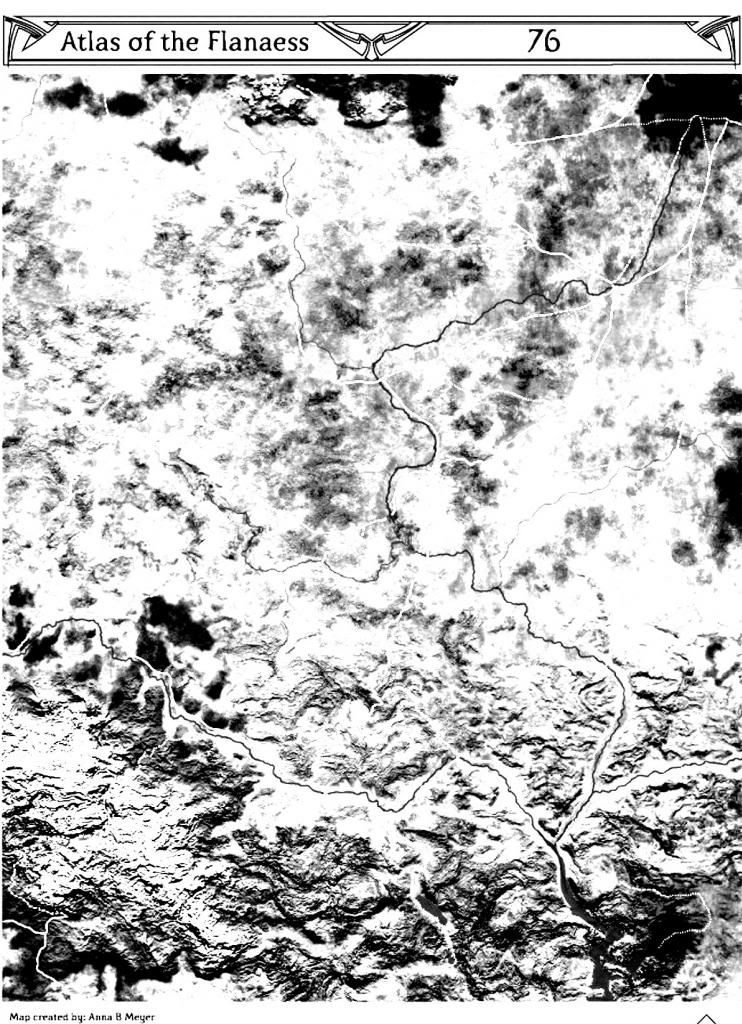
Here's a black and white, high-contrast version of Anna's full section 76 with all the layers except for terrain and roads turned off. It's pretty easy to do; layers are on the left side of the document, underneath the paperclip symbol.
|
|
|
GreySage
Joined: Jul 26, 2010
Posts: 2701
From: LG Dyvers
Send private message
|
Wed Jan 09, 2013 10:22 am
|
REPLY
QUOTE
TOP
|
|
Awesome, Rasgon! Thanks for explaining how to do that.
SirXaris
|
|
|
Adept Greytalker
Joined: Aug 28, 2004
Posts: 348
Send private message
|
Thu Jan 10, 2013 9:02 am
|
REPLY
QUOTE
TOP
|
|
Cool, many thanks, Rasgon! In the meantime, I have started working on something on my own - let's see if I can present it to you over the weekend!
_________________
"A Minstrel's Memory": PBPs & Other Games, since 2005.
|
|
|
|