| Author |
Message |
Master Greytalker
Joined: Jul 13, 2002
Posts: 1077
From: Orlane, Gran March
Send private message
|
Sat Jun 24, 2006 6:48 am
The Size of the Flaness
|
 REPLY
QUOTE
TOP
REPLY
QUOTE
TOP
|
|
I am sure that this has been done many times. However, I wanted to make sure my calculations are correct. On the Dungeon 4 part map, there are 188 hexes across, numbering every other hex.
If they are 30 miles across, and the hexes overlap creating 1.5 hexes per two, then is this equation and size correct?
188 x 1.5 x 30 = 8460 miles from the Sea of Dust to the Solnor?
North South it seems to be:
110 x 30 = 3000 miles
Thus we have a world that is:
3000 x 8460= 25 million sq miles. Or, an area the same as Asia?
|
|
|
Journeyman Greytalker
Joined: Feb 01, 2005
Posts: 196
From: Columbus, Ohio
Send private message
|
Sat Jun 24, 2006 11:41 am
|
REPLY
QUOTE
TOP
|
|
This article may help... or just add confusion.
http://www.dracheninsel.de/dracheninsel/add/greyhawk/measuring.htm
But based on the article we find...
"At a scale of 30 miles/hex along the 35 N parallel, that's a distance of 3893.76 miles (almost 4 thousand miles from the Sea Barons to the lands west of Ull!)"
Don't know if this helped.
Skech
|
|
|
GreySage
Joined: Aug 03, 2001
Posts: 3310
From: Michigan
Send private message
|
Sat Jun 24, 2006 1:15 pm
|
REPLY
QUOTE
TOP
|
|
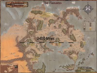
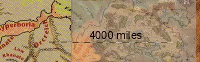
Here's what I determined using the scale on the Living Greyhawk Gazetteer map. That map shows clearly what 800 miles looks like, so I cut and pasted the image in a straight line to see what 2400 miles and 4000 miles was.
|
|
|
Master Greytalker
Joined: Jul 13, 2002
Posts: 1077
From: Orlane, Gran March
Send private message
|
Sat Jun 24, 2006 4:22 pm
|
REPLY
QUOTE
TOP
|
|
Ok, I found the error... the bottom numbers begin at 106. Thus there are 82 x 1.5 hexes x 30 = 3690 miles.
Ok, that makes more sense.
|
|
|
Apprentice Greytalker
Joined: Aug 07, 2005
Posts: 15
Send private message
|
Sat Jun 24, 2006 4:46 pm
Re: The Size of the Flaness
|
REPLY
QUOTE
TOP
|
|
First time posting here, so please bear with me.
| Anced_Math wrote: |
| I am sure that this has been done many times. However, I wanted to make sure my calculations are correct. On the Dungeon 4 part map, there are 188 hexes across, numbering every other hex. |
This is where you got tripped up. The southeast part of the map (I don't remember which issue it came from) shows the vertical axis hexes numbered up to 105, while the horizontal axis starts at 106 and runs to 188.
**EDIT** I see you already figured this out so away it goes. You've got an area here slightly larger than the US or Canada, but nowhere near as large as Russia.
|
|
|
Master Greytalker
Joined: Jul 13, 2002
Posts: 1077
From: Orlane, Gran March
Send private message
|
Sat Jun 24, 2006 5:16 pm
|
REPLY
QUOTE
TOP
|
|
Hunter, welcome, and please post again. If you have a knack (and it appears that you do) for these sizes, a list of equivalent sizes would be useful. How big is Keoland? Aerdy? Nyrond? Furyondy? The Sea of Dust? Geoff? Medegia?
One of the things that I think GH lacks is a relationship to the real world, at least in terms of size and scope.
|
|
|
Journeyman Greytalker
Joined: Oct 08, 2003
Posts: 157
From: Pretoria
Send private message
|
Mon Jun 26, 2006 6:22 am
|
REPLY
QUOTE
TOP
|
|
Yeah! I agree with Anced_Math, even in the older Faerun boxed set there was a comparison between North America and the Realms.
I find it difficult (being in South Africa) to locate good info regarding the rest of Oerth. This site is absolutely brilliant from a sourcing info perspective, amongst other reasons. 
|
|
|
Site Theocrat
Joined: Aug 15, 2003
Posts: 235
From: WoG 2.0
Send private message
|
Mon Jun 26, 2006 11:41 am
Measureing Oerth
|
REPLY
QUOTE
TOP
|
|
Hi all -
Holian did an article in OJ 4 (iirc) that is about measuring the Flananess as based on the original Darlene map. On that map, the 30 mile hexes would actually shrink the further north the hex went. Because I've lost my hdd do a data crash (what happens when your back up dies?), I know longer have that OJ (bu it can be found at OerthJournal.com) but I don't have my hard work on my OJ article called Weathering the Flanaess. It would only help in this case for the latitude and longitudual lines and when and where I got my resources. And maybe the city longitude / latitude that I had developed. Again, all based on the Darlene maps
My biggest complaint about GH in general is authors not doing enough research on their topic. There should be several sources that give reason for whatever it is that you're writting about. Even if it is only hinted and a one line sentance.
As such, to really get an accurate girth of Oerth at the equator, you should look at that OJ article, as well as GreySpace. If you get Rich Tricky on this thread or Grodog, I'm sure they'd be able to point to some direct references of girth.
Be Well.
Theocrat Issak
_________________
Theocrat Issak
|
|
|
|