Sat Aug 14, 2010 5:18 am
Huzzah! Thillonrian Map
|
 REPLY
QUOTE
TOP
REPLY
QUOTE
TOP
|
|
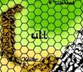
So I was looking for my copy of Swords of Daimyo for another thread and accidentally came upon a folder that held a bunch of maps that I've been searching for for years. Ain't that how it always goes? (I still never found the module) Anyhoo, these maps are hand-drawn and colored blow up projections of the Thillonrian Peninsula that I made for my 2e campaign back in the heyday of Five Shall Be One and the Vikings Handbook. The scale is one hex equals 10 miles.
I've only scanned and cobbled together one section so far. (It was a huge project altogether: 11-12 maps) It's also a big file because I haven't quite figured what's readable (it is written in pencil after all). I suppose if I get the urge I'll scan more or even someday re-label them, but for now here is the teaser map of the "Dain Lands" in Cruskii where my friend's PC, Valkaun Dain hailed from.
http://www.greyhawkonline.com/mortellan/ghfiles/dainland1.jpg
|