|
|
|
| Posted on Wed, February 11, 2004 by Legate |
|
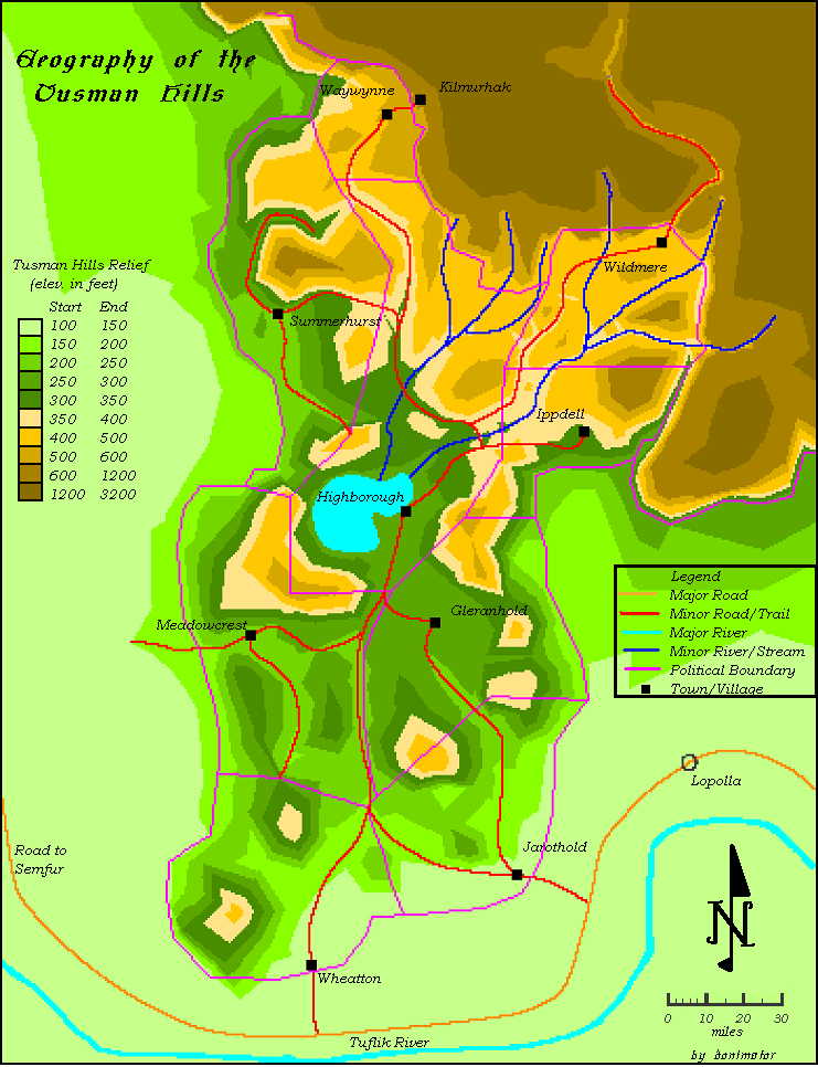
donimator writes "To many, the Tusman Hills have always been a place to avoid on the trade route from Lopolla to Semfur. The rugged hills and the fierce tribesman who inhabit them are enough to convince people to stay away. Isolated for centuries since fleeing the Twin Cataclysms, the Oeridian settlers of these hills were disinterested in the politics of the neighboring states of Ket and Tusmit. They created a sustaining life that kept them from the affairs, and the attention, of others. However, the hills hold vibrant communities, a thriving society that has withstood the test of time. Take a look at what lies inside the Tusman Hills...
Tusman Hills Map
By: donimator
Used with Permission. Do not repost without obtaining prior permission from the author.
Read the Tusman Hills articles here:
Gazatteer of the Tusman Hills
History of the Tusman Hills
Map of the Tusman Hills:
 " "
|
|
|
|
|
| |
|
|
|
Average Score: 3.25
Votes: 4

|
|
|
|
|
|
|
| | The comments are owned by the poster. We aren't responsible for their content. |
|
|
|
|
|
| No Comments Allowed for Anonymous, please register |
|
|
|
|
Re: Tusman Hills Map (Score: 1)
by donimator on Thu, February 12, 2004
(User Info | Send a Message) | | ...actually the topographical part wasn't too hard. I used AutoCAD Land Desktop - I just had to set elevations for points on the features suchs as the roads and rivers, add a few spot elevations in between, and everything was automated. The program makes a true 3d model of the entire surface that can be updated at anytime. The only freehand drawing I had to do was to draft in the roads, rivers and political boundaries |
]
]
Re: Tusman Hills Map (Score: 1)
by donimator on Thu, February 12, 2004
(User Info | Send a Message) | | Land Desktop is one of AutoCAD's latest and greatest. I work in the engineering field and am lucky enough to have access to these programs (since a license for 1 seat of Land Desktop is about $7000). It can really do amazing stuff, but has none of the built-in routines of say, CC2. While it could ultimately be superior to CC2 for fanatsy mapping, one would have to do a lot of customizing to make it easy to use. I chose to try Land Desktop for this map because the defining feature of the Tusman Hills region is the terrain and I wanted to bring that out. |
]
Good Job (Score: 1)
by Greyson on Sun, February 15, 2004
(User Info | Send a Message) http://www.donkbrown.com | Not too bad, donimator. topographical maps are always useful. The cool thing about your is the location. The Tusman hills are interesting tome because of tensions in the area with countries near them and the Bramblewood forest.
Thanks for the effort. |
]
|
|
|
|
|
|